Skyline Trail Crossing of Route 28 in the Blue Hills Reservation

TECHNICAL MEMORANDUM
DATE: October 7, 2024
TO: Jen Klein, Friends of the Blue Hills
Allison Ruel, City of Quincy
FROM: Casey Cooper, Boston Region Metropolitan Planning Organization
RE: Skyline Trail Crossing of Route 28 in the Blue Hills Reservation
The Skyline Trail is a popular hiking route within the Blue Hills Reservation. People traveling along the Skyline Trail enjoy nature and scenic views for much of their outing, but motor vehicles traveling along Route 28 introduce a conflict point along the path. The trail’s Route 28 crossing is located near the crest of a hill and along a curve, making it difficult for people driving and people hiking to see one another. The Friends of the Blue Hills and the City of Quincy reached out to Boston Region Metropolitan Planning Organization (MPO) staff to improve the safety of the Skyline Trail crossing of Route 28.
MPO staff analyzed vehicle volumes and vehicle speeds both north and south of the Skyline Trail on Route 28 and studied pedestrian volumes at the Skyline Trail entrances on both sides of Route 28. Vehicle volumes were lowest on Route 28 on weekends, when vehicle speeds were fastest, while the Skyline Trail experienced the greatest level of use on weekends. MPO staff propose modifications to the current Route 28 crossing location to encourage safety, especially on weekends when high vehicle speeds are coupled with high pedestrian volumes.
The Skyline Trail crossing of Route 28 is currently unmarked by a crosswalk. The only notice provided to motorists regarding the presence of the crossing are two signs facing oncoming traffic on either side of the Skyline Trail. MPO staff recommend adding crosswalk markings across Route 28 to increase driver awareness of the Skyline Trail’s presence. Staff also propose raising the roadway at the crossing to slow the speeds at which people drive through the location. MPO staff also suggest adding pedestrian bump outs to narrow the roadway and improve crossing visibility for both drivers and trail users. These changes should be accompanied by increased signage about the crossing to raise awareness. Finally, the addition of rectangular rapid flashing beacons to each side of the Skyline Trail crossing would allow hikers to alert drivers to their presence.
This memorandum reports the findings of a transportation study of the location where the Blue Hills Reservation’s Skyline Trail crosses Route 28 in Quincy, Massachusetts. The study was conducted through the Community Transportation Technical Assistance (CTTA) Program administered by staff to the Boston Region MPO. The CTTA Program provides technical analysis and support to municipal officials about local transportation issues in the Boston metropolitan region.
The Friends of the Blue Hills and the City of Quincy contacted MPO staff regarding the safety of Route 28’s Skyline Trail pedestrian crossing. The organization and the City requested that MPO staff study conditions for trail users where the Skyline Trail crosses Route 28. Both entities expressed interest in installing pedestrian signals at the location because it is one of the most used roadway crossings in the Blue Hills Reservation. Figure 1 illustrates the location of the Skyline Trail within the Blue Hills Reservation and identifies where the trail crosses Route 28 in Quincy. This study identified improvements that would facilitate a safer and more comfortable Route 28 crossing for people traveling along the Skyline Trail.
Figure 1
Skyline Trail Crossing of Route 28 in the Blue Hills Reservation

This study location includes multiple jurisdictions. The crossing itself is within the City of Quincy, but Route 28 is the jurisdiction of the Massachusetts Department of Transportation (MassDOT). Quincy is served by MassDOT District 6. The Blue Hills Reservation is the responsibility of the Department of Conservation and Recreation (DCR). A kick-off meeting held on August 4, 2022, convened these stakeholders and the Friends of the Blue Hills to discuss the existing conditions, issues, and concerns at the study location.
The Skyline Trail is a 7.5-mile route that covers the length of the Blue Hills Reservation, stretching from its eastern end to the conservation area’s western bounds.1 The trail climbs many of the Blue Hills Reservation’s peaks and is known for providing beautiful views, which contribute to the Skyline Trail’s popularity as a hiking route within the Blue Hills Reservation. The trail’s intersection with Route 28 introduces a stressful contrast to the natural environment that hikers experience along the majority of the Skyline Trail’s path.
Route 28 is a principal arterial roadway that travels in a north-south direction through the Blue Hills Reservation, bisecting the conservation area. Two buses travel along Route 28, the Massachusetts Bay Transportation Authority (MBTA) Bus 240 and Brockton Area Transit Authority Bus 12, but neither stops in the Blue Hills Reservation. Where the two-lane roadway meets the Skyline Trail, the asphalt measures approximately 40 feet wide, with 25 feet allocated to vehicle travel lanes and 15 feet allocated to roadway shoulders. The location where the Skyline Trail crosses Route 28 is not indicated by any pavement markings such as a crosswalk. Hikers traveling the length of the Skyline Trail meet Route 28 at a curve in the roadway located at the peak of a hill, making visibility at the intersection difficult for both people driving and people hiking. Trail users can see vehicles approaching the crossing from the north along Route 28, but it is difficult to see vehicles south of the crossing. Guardrails are present on both sides of Route 28 north of the Skyline Trail crossing and on the west side of Route 28 south of the crossing.
On either side of the Skyline Trail Crossing, signage alerts drivers to the presence of the hiking trail. Two hiking trail signs (MUTCD RS-068), each above a sign reading “TRAIL XING AHEAD,” have been installed on either side of the Skyline Trail along Route 28. Figure 2 shows these signs, which are located approximately 420 feet north (left) and 450 feet south (right) of the Skyline Trail respectively.
Figure 2
Hiking Trail Signs Accompanied by TRAIL XING AHEAD Text

Source: Google Street View (September 2023)
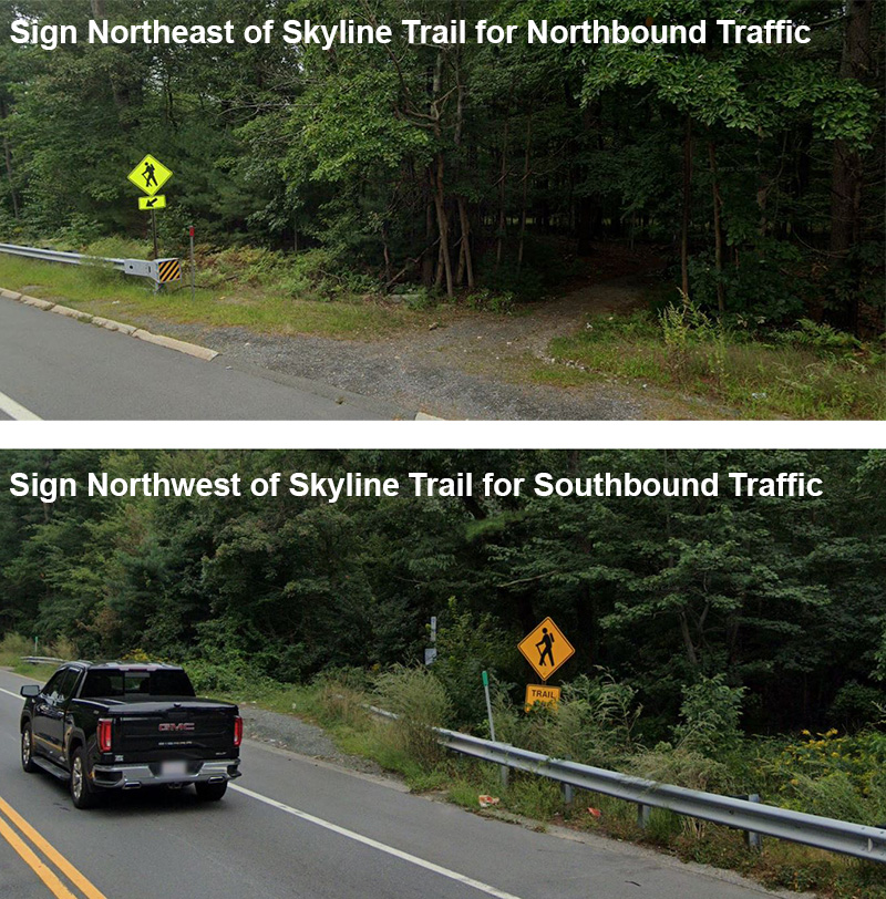
When northbound drivers reach the crossing, a second hiking trail sign is visible just north of the trail. This sign is paired with an arrow that points downward to the left (MUTCD W16-7P), as illustrated in Figure 3. Figure 3 also shows the second hiking trail sign that southbound drivers encounter as they near the Skyline Trail, installed just north of the crossing as well. This hiking trail sign is located above a sign reading “TRAIL XING” (W11-15P).
Figure 3
Hiking Trail Signs for Route 28 Traffic
Source: Google Street View (September 2023)
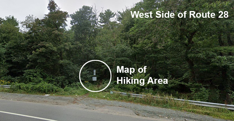
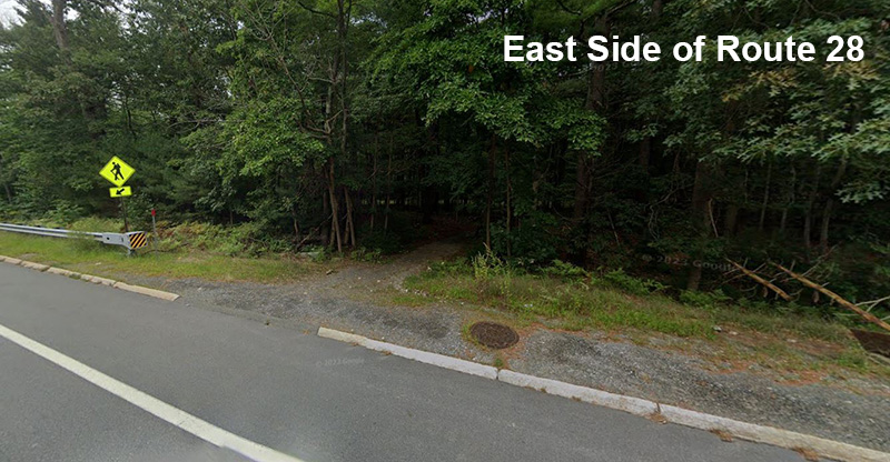
The entrance to the Skyline Trail on the west side of Route 28 includes a map of the hiking area, but the trail entrance on the east side of the roadway is unmarked aside from the hiking trail sign with an arrow below the sign (Figure 4).
Figure 4
Skyline Trail Entrances
Source: Google Street View (September 2023)
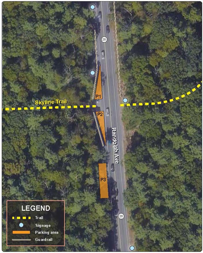
There is space for trail users to park near the entrance to the Skyline Trail on the west side of Route 28. Additional space for vehicles can be found on the west side of the roadway approximately 125 feet south of the crossing. Figure 5 illustrates the location of these two parking locations (P1 and P2 respectively) and the placement of the hiking trail signage along Route 28 for the Skyline Trail crossing.
Figure 5
Skyline Trail Crossing of Route 28, Current Conditions
A parking area for more Blue Hills Reservation trails (P3) is located on the west side of Route 28 approximately 0.2 miles south of the Skyline Trail crossing. Skyline Trail users could potentially park at this location, which is slightly larger than the parking areas closest to the Skyline Trail, and walk north to access the Skyline Trail, but Route 28 does not include safe pedestrian facilities such as sidewalks or shared-use paths.
Prior to engaging in this study, MPO staff received input about a variety of factors within the vicinity of the Skyline Trail crossing of Route 28 that troubled the Friends of the Blue Hills. They were primarily concerned about the speed and volume of traffic along Route 28, which they explained makes crossing the roadway very difficult, especially for individuals with disabilities or mobility impairments. The organization shared anecdotally that many people traveling along the Skyline Trail turn around once they reach Route 28 to avoid crossing amid the vehicle traffic, which limits use of the Blue Hills Reservation and prevents access to both sides of the conservation area.
The Friends of the Blue Hills also shared their concerns about the impact of Route 28 on wildlife. The Friends explained that the roadway degrades the wildlife habitat and restricts the movement of animals by dividing the Blue Hills Reservation. In addition, the Friends of the Blue Hills expressed interest in a wildlife tunnel if one is warranted at the location, but such an assessment is outside the scope of work for this study.
Finally, the Friends of the Blue Hills would like to explore how bicycle and pedestrian travel could be accommodated along Route 28 from south of the I-93 and I-95 interchange to increase access to the Skyline Trail via both modes. Exploring this idea was also was outside the scope of this study, although future work in this area could analyze Route 28 south of the Skyline Trail to provide recommendations that would improve the safety of walking and bicycling along the roadway.
MPO staff completed Unlocking the Blue Hills in 2022, an analysis of the equity of access to the Blue Hills Reservation.2 The study was inspired by the challenges of accessing the Blue Hills Reservation faced by residents of the majority-minority and transit-dependent southern Boston neighborhoods closest to the conservation area. One area of particular concern for stakeholders involved in the study was the difficulty of accessing the Blue Hills from Mattapan, a majority-minority neighborhood with a relatively high percentage of low-income and zero-car households located less than five miles from the Blue Hills.
Key recommendations from the analysis took the form of transit service improvements from April 1 through October 31, the peak visitor season for the Blue Hills Reservation. Options ranged from modifying existing MBTA service to providing new bus services that would create new stops within the conservation area. The intent of the study recommendations was to increase access to the Blue Hills Reservation, particularly for populations who have not been able to easily visit the natural resource in the past. If implemented, the transit improvements have the potential to increase the volume of visitors to the Blue Hills Reservation and its trails. The Skyline Trail, as one of the conservation area’s most popular routes, could see considerable increase in usage. It will therefore be particularly important to ensure the safety of the trail’s Route 28 crossing for people hiking and increase driver awareness of the crossing.
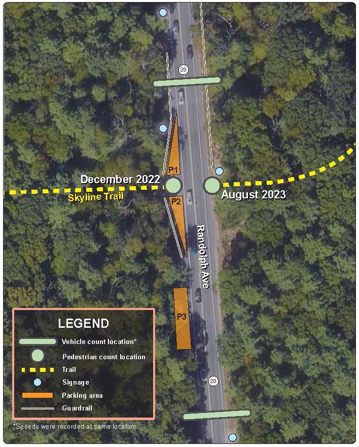
MPO staff analyzed the travel behavior of both people walking and driving where the Skyline Trail crosses Route 28 in the Blue Hills Reservation. Vehicle speed and volume data for Route 28 were collected in 2022 both north and south of the Skyline Trail crossing from Tuesday, September 27 to Monday, October 3.3 MPO staff also tested their new automated pedestrian count sensor unit, the Eco-Counter Mobile MULTI, at the study location.4 MPO staff initially installed the pedestrian counting device from December 2, 2022, to December 12, 2022, and then counted people walking at the location again from August 14, 2023, to August 29, 2023.5 These data collection locations are illustrated in Figure 6.
Figure 6
Skyline Trail Crossing of Route 28
More vehicles traveled along Route 28 on weekdays than they did during the weekends. Route 28 experienced the lowest weekday vehicle volumes during AM peak hours for southbound travel, with an average volume of 719 vehicles. Conversely, the weekday AM peak northbound and PM peak southbound both averaged a volume that exceeded 1,400 vehicles. On weekends, peak-hour average volumes ranged from approximately 600 to 850 vehicles.
Table 1
Vehicle Volumes along Route 28 North of the Skyline Trail Crossing
Day of the Week |
Date |
Total Daily Vehicles |
AM Peak a |
PM Peak a |
|||||||||
Northbound |
Southbound |
Northbound |
Southbound |
Northbound |
Southbound |
||||||||
Hour |
Volume |
Hour |
Volume |
Hour |
Volume |
Hour |
Volume |
||||||
Monday |
10/3/2022 |
7,583 |
3,937 |
7:00 AM |
1,381 |
9:00 AM |
657 |
1:00 PM |
558 b |
1:00 PM |
472 b |
||
Tuesday |
9/27/2022 |
5,159 |
15,450 |
N/A c |
N/A c |
12:00 PM |
761 |
4:00 PM |
1,042 |
6:00 PM |
1,402 |
||
Wednesday |
9/28/2022 |
15,432 |
13,831 |
8:00 AM |
1,366 |
9:00 AM |
685 |
6:00 PM |
1,130 |
5:00 PM |
1,445 |
||
Thursday |
9/29/2022 |
15,266 |
14,408 |
8:00 AM |
1,468 |
9:00 AM |
682 |
5:00 PM |
938 |
5:00 PM |
1,438 |
||
Friday |
9/30/2022 |
16,768 |
14,191 |
8:00 AM |
1,409 |
9:00 AM |
812 |
7:00 PM |
1,284 |
5:00 PM |
1,423 |
||
Saturday |
10/1/2022 |
11,053 |
11,034 |
12:00 PM |
738 |
12:00 PM |
690 |
3:00 PM |
819 |
1:00 PM |
1010 |
||
Sunday |
10/2/2022 |
9,785 |
9,015 |
11:00 AM |
655 |
12:00 PM |
547 |
3:00 PM |
779 |
4:00 PM |
694 |
||
Average Overall |
11,578 |
11,695 |
9:00 AM |
1,170 |
10:17 AM |
691 |
4:40 PM |
999 |
4:20 PM |
1,235 |
|||
Weekday Average |
12,042 |
12,363 |
7:45 AM |
1,406 |
9:36 AM |
719 |
5:30 PM |
1,099 |
5:15 PM |
1,427 |
|||
Weekend Average |
10,419 |
10,025 |
11:30 AM |
696.5 |
12:00 PM |
618.5 |
3:00 PM |
799 |
2:30 PM |
852 |
|||
a AM and PM Peak volumes represent the AM and PM hour during which the greatest number of vehicles were recorded. The noon (12:00 PM) hour is considered the final hour of the AM period.
b MPO staff omitted the Monday (10.03.22) PM peak volume from the overall and weekday PM peak-hour averages because vehicles were only counted until 2:00 PM on Monday afternoon.
c Data collection north of the Skyline Trail for northbound vehicles did not begin until 4:00 PM on Tuesday (9.27.22), so AM peak volumes for northbound vehicles north of the Skyline Trail are not available for Tuesday morning.
N/A = Not Applicable
Table 2
Vehicle Volumes along Route 28 South of the Skyline Trail Crossing
Day of the Week |
Date |
Total Daily Vehicles |
AM Peak a |
PM Peak a |
|||||||
Northbound |
Southbound |
Northbound |
Southbound |
Northbound |
Southbound |
||||||
Hour |
Volume |
Hour |
Volume |
Hour |
Volume |
Hour |
Volume |
||||
Monday |
10/3/2022 |
6,871 |
3,282 |
8:00 AM |
1,407 |
9:00 AM |
634 |
N/Ab |
N/Ab |
N/Ab |
N/Ab |
Tuesday |
9/27/2022 |
14,657 |
8,458 |
8:00 AM |
1,505 |
N/Ac |
N/Ac |
4:00 PM |
1,013 |
6:00 PM |
1,401 |
Wednesday |
9/28/2022 |
15,233 |
13,456 |
8:00 AM |
1,458 |
9:00 AM |
675 |
6:00 PM |
1,094 |
5:00 PM |
1,409 |
Thursday |
9/29/2022 |
15,011 |
13,961 |
8:00 AM |
1,471 |
9:00 AM |
647 |
5:00 PM |
880 |
5:00 PM |
1,383 |
Friday |
9/30/2022 |
16,376 |
13,592 |
8:00 AM |
1,463 |
9:00 AM |
784 |
5:00 PM |
1,229 |
6:00 PM |
1,360 |
Saturday |
10/1/2022 |
10,565 |
10,641 |
12:00 PM |
715 |
12:00 PM |
685 |
3:00 PM |
786 |
1:00 PM |
974 |
Sunday |
10/2/2022 |
9,334 |
8,743 |
11:00 AM |
627 |
12:00 PM |
547 |
3:00 PM |
756 |
3:00 PM |
693 |
Average Overall |
12,578 |
10,305 |
9:00 AM |
1,235 |
10:00 AM |
662 |
4:20 PM |
960 |
4:20 PM |
1,203 |
|
Weekday Average |
13,630 |
10,550 |
8:00 AM |
1,461 |
9:00 AM |
685 |
5:00 PM |
1,054 |
5:30 PM |
1,388 |
|
Weekend Average |
9,950 |
9,692 |
11:30 AM |
671 |
12:00 PM |
616 |
3:00 PM |
771 |
2:00 PM |
834 |
|
a AM and PM Peak volumes represent the AM and PM hour during which the greatest number of vehicles were recorded. The noon (12:00 PM) hour is considered the final hour of the AM period.
b Data collection south of the Skyline Trail for both directions of travel ended at 1:00 PM on Monday (10.03.22). The noon (12:00 PM) hour is considered the final hour of the AM period, so PM peak volumes for both directions of travel south of the Skyline Trail are not available.
c Data collection south of the Skyline Trail for southbound vehicles did not begin until 3:00 PM on Tuesday (09.27.22) and therefore did not include AM peak volumes.
N/A: Not Applicable
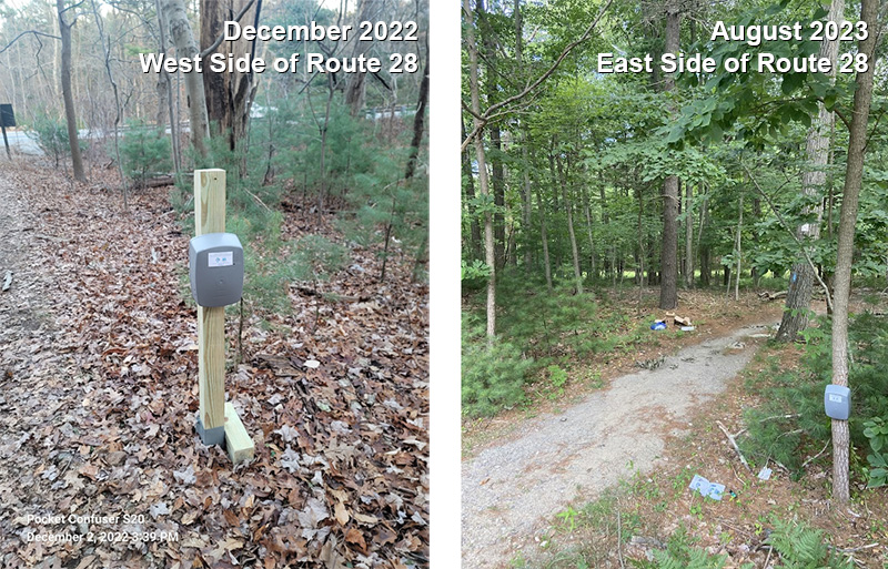
Data on pedestrian volumes were collected using an automated pedestrian count sensor, the Eco-Counter Mobile MULTI, which MPO staff installed once on either side of Route 28 at the Skyline Trail’s entrances. MPO staff first installed the count sensor on the west side of Route 28 for 10 days in December 2022. When MPO staff installed the device at the study location the second time, they did so on the east side of Route 28 for 15 days in August 2023. These locations are illustrated in Figure 7, which documents both count sensor installations.
Figure 7
Count Sensor Installations
The number of people recorded traveling along the Skyline Trail at Route 28 varied considerably day-to-day, but the overall trends in both December 2022 (Table 3) and August 2023 (Table 4) showed that more people hiked along the Skyline Trail on weekends than on weekdays. Surprisingly, the highest number of total hikers counted along the trail did not occur during August, but instead on Sunday, December 4. Many of the weekdays from the two different collection periods shared comparable volumes, but Wednesdays and Thursdays in August 2023 greatly exceeded the December 2022 volumes (Table 5). Saturdays and Sundays were popular at both times of year, but the Saturday average was higher in August 2023 while December 2022 had a busier Sunday average (Table 5).
It is important to note that, at the time of data collection, MPO staff only owned one automatic pedestrian count sensor, so the data from each collection period only reflect the number of people present on one side of Route 28. Considering the Friends of the Blue Hills’ anecdotes about hikers turning around when they reach Route 28 rather than crossing the high-speed roadway, it is possible that the pedestrian volumes collected for this study are incomplete. For a more accurate representation of pedestrian behavior at the Skyline Trail’s crossing of Route 28, MPO staff recommend collecting pedestrian volumes at the Skyline Trail simultaneously on both sides of Route 28.
Table 3
December 2022 Skyline Trail Pedestrian Volumes at Route 28
Date |
Day of the Week |
Total |
Direction |
|
West to the Skyline Trail |
East to Route 28 |
|||
12/2/22 |
Friday |
1 |
1 |
0 |
12/3/22 |
Saturday |
54 |
26 |
28 |
12/4/22 |
Sunday |
198 |
108 |
90 |
12/5/22 |
Monday |
11 |
7 |
4 |
12/6/22 |
Tuesday |
19 |
11 |
8 |
12/7/22 |
Wednesday |
4 |
1 |
3 |
12/8/22 |
Thursday |
20 |
13 |
7 |
12/9/22 |
Friday |
13 |
7 |
6 |
12/10/22 |
Saturday |
83 |
40 |
43 |
12/11/22 |
Sunday |
68 |
33 |
35 |
12/12/22 |
Monday |
12 |
7 |
5 |
Table 4
August 2023 Skyline Trail Pedestrian Volumes at Route 28
Date |
Day of the Week |
Total |
Direction |
|
West to Route 28 |
East to the Skyline Trail |
|||
8/14/23 |
Monday |
9 |
6 |
3 |
8/15/23 |
Tuesday |
7 |
3 |
4 |
8/16/23 |
Wednesday |
81 |
51 |
30 |
8/17/23 |
Thursday |
49 |
25 |
24 |
8/18/23 |
Friday |
8 |
3 |
5 |
8/19/23 |
Saturday |
128 |
60 |
68 |
8/20/23 |
Sunday |
109 |
55 |
54 |
8/21/23 |
Monday |
15 |
9 |
6 |
8/22/23 |
Tuesday |
26 |
12 |
14 |
8/23/23 |
Wednesday |
41 |
21 |
20 |
8/24/23 |
Thursday |
38 |
14 |
24 |
8/25/23 |
Friday |
1 |
0 |
1 |
8/26/23 |
Saturday |
71 |
34 |
37 |
8/27/23 |
Sunday |
123 |
58 |
65 |
8/28/23 |
Monday |
23 |
14 |
9 |
8/29/23 |
Tuesday |
8 |
5 |
3 |
Table 5
Average Daily Pedestrians by Day of the Week
Day of the Week |
Average Daily Pedestrians |
|
December 2022 |
August 2023 |
|
Monday |
11.5 |
15.667 |
Tuesday |
19.0 |
13.667 |
Wednesday |
4.0 |
61.0 |
Thursday |
20.0 |
43.5 |
Friday |
7.0 |
4.5 |
Saturday |
68.5 |
99.5 |
Sunday |
133.0 |
116.0 |
The speed limit at the study location is posted at 50 miles per hour (mph). Vehicle traffic traveled at the highest recorded speeds while traveling northbound after passing the Skyline Trail (Tables 6 and 7). Overall, however, average speeds at the study location did not exceed the speed limit at either data collection location for both directions of travel. The 85th percentile speeds, reflecting speeds at which 85 percent of vehicles drove, hovered around the 50-mph speed limit for both locations and directions of travel, except for northbound traffic after crossing the Skyline Trail. People driving in this direction were recorded to have an 85th percentile speed of 56.8 mph, which is more than 5 mph above the posted speed limit.
Table 6
Vehicle Speeds along Route 28 North of the Skyline Trail Crossing*
Day of the Week |
Date |
Average Speed |
85th Percentile Speed |
||
Northbound |
Southbound |
Northbound |
Southbound |
||
Monday |
10/3/2022 |
45.4 |
45.1 |
56.1 |
54.8 |
Tuesday |
9/27/2022 |
46.8 |
39.1 |
57.4 |
49.6 |
Wednesday |
9/28/2022 |
45.1 |
40.3 |
54.9 |
50.6 |
Thursday |
9/29/2022 |
45.1 |
40.6 |
55.1 |
49.7 |
Friday |
9/30/2022 |
43.3 |
41.4 |
55.0 |
50.1 |
Saturday |
10/1/2022 |
50.4 |
44.4 |
58.8 |
53.4 |
Sunday |
10/2/2022 |
50.9 |
45.2 |
60.0 |
55.6 |
Average Overall |
46.7 |
42.3 |
56.8 |
52.0 |
|
Weekday Average |
45.1 |
41.3 |
55.7 |
51.0 |
|
Weekend Average |
50.7 |
44.8 |
59.4 |
54.5 |
|
* The location of the speed data collection is illustrated in Figure 6.
mph = miles per hour.
Table 7
Vehicle Speeds along Route 28 South of the Skyline Trail Crossing*
Day of the Week |
Date |
Average Speed |
85th Percentile Speed |
||
Northbound |
Southbound |
Northbound |
Southbound |
||
Monday |
10/3/2022 |
40.8 |
41.5 |
51.0 |
52.4 |
Tuesday |
9/27/2022 |
39.7 |
35.2 |
51.3 |
44.6 |
Wednesday |
9/28/2022 |
39.8 |
37.3 |
50.6 |
48.0 |
Thursday |
9/29/2022 |
40.5 |
37.9 |
51.3 |
47.4 |
Friday |
9/30/2022 |
39.4 |
38.2 |
51.0 |
48.1 |
Saturday |
10/1/2022 |
43.0 |
40.9 |
53.8 |
50.4 |
Sunday |
10/2/2022 |
42.8 |
41.1 |
54.5 |
52.3 |
Average Overall |
40.9 |
38.9 |
51.9 |
49.0 |
|
Weekday Average |
40.0 |
38.0 |
51.0 |
48.1 |
|
Weekend Average |
42.9 |
41.0 |
54.2 |
51.4 |
|
* The location of the speed data collection is illustrated in Figure 6.
mph = miles per hour.
Vehicle speeds were found to be faster on the weekends, compared to weekdays. This coincides with the days of the week when vehicle volumes were lowest. Unfortunately, weekends are also when the Skyline Trail experiences the greatest level of use (see Section 3.2). To encourage the greatest level of safety, especially when high vehicle speeds are coupled with high pedestrian volumes on weekends, modifications need to be made to the current Route 28 crossing location.
While overall vehicle speeds at the study location are within a reasonable margin of the posted speed limit, the experience of trail users when trying to cross Route 28 is negatively impacting their ability to travel along the Skyline Trail. This suggests that vehicle speeds need to be reduced at the crossing location. In addition to lowering the speed limit, there are changes that can be made to the physical configuration of the roadway and the trail entrances to encourage safer driver behavior and greater pedestrian visibility.
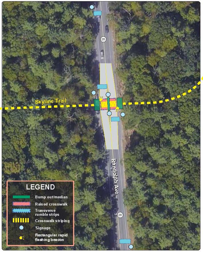
MPO staff propose a number of recommended changes to Route 28 where the Skyline Trail crosses the roadway. To improve the safety of the Skyline Trail crossing of Route 28 for all users, it will be important to increase awareness of the crossing, improve visibility, and slow vehicle speeds. Striping the location with high-visibility crosswalk markings and improving signage leading up to and at the crossing are the first steps to drawing drivers’ attention to the presence of the Skyline Trail. However, additional countermeasures detailed in the following sections would need to accompany the roadway striping to ensure that the location does not provide a false sense of security.
The other countermeasures MPO staff recommend include installing rumble strips ahead of the crossing, adding a median and pedestrian bump outs to narrow the roadway and improve crossing visibility for both drivers and trail users, and raising the roadway at the location of the Skyline Trail to slow the speeds at which people drive through the conflict point. MPO staff also suggest installing rectangular rapid flashing beacons on each side of Route 28 at the study location to allow hikers to alert drivers of their presence. All these changes should be accompanied by increased Skyline Trail crossing signage to raise driver awareness of the potential for crossing hikers.
Adding high-visibility crosswalk markings to the trail crossing is a quick and low-cost modification that has the potential to substantially improve the location for Skyline Trail hikers. Improvements to the visibility and frequency of the signage along Route 28, when paired with crosswalk markings, will raise driver awareness of the Skyline Trail’s presence and the potential for crossing hikers.
Clear hiking trail signage should inform drivers of the trail crossing location. A sign that specifies that the hiking trail is the Skyline Trail also would be informative for people interested in accessing the Blue Hills Reservation’s recreational offerings. In addition, more signage at the trailheads on each side of the roadway, including a map of the Blue Hills Reservation on the east side of the roadway, would be helpful for hikers’ navigation and trip-planning purposes. MassDOT does not typically allow parking on its roadways, however, so any proposal to formally sign the parking areas on the west side of Route 28 is likely to be rejected.
Finally, to communicate that motorists are expected to slow their vehicles at the crossing location, MPO staff recommend installing signage ahead of the Skyline Trail crossing in both directions that indicates a speed limit of 35 mph or slower.
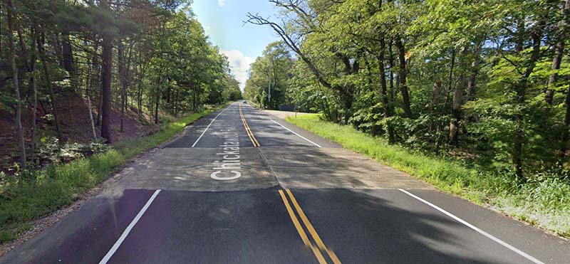
Installing transverse rumble strips both north and south of the Skyline Trail at two points, one approximately 300 feet before the crossing and another immediately before it, will alert drivers to a change in the roadway that requires their attention. These grooves in the road surface are installed within the travel lane perpendicular to the direction of travel, creating vibrations and noise within vehicles that would help indicate the presence of the Skyline Trail crossing to motorists.
MPO staff recommend the use of transverse rumble strips instead of speed bumps because MassDOT does not install speed bumps on state highways. MassDOT is concerned about their impact on snowplows and the ability of speed bumps to damage vehicles or lead to crashes on high-speed roadways. Fortunately, there is already precedent in the Blue Hills Reservation for the installation of transverse rumble strips where Purgatory Road meets Chickatawbut Road (Figure 8).
Figure 8
Transverse Rumble Strips on Chickatawbut Road at Purgatory Road
Source: Google Street View (August 2018)
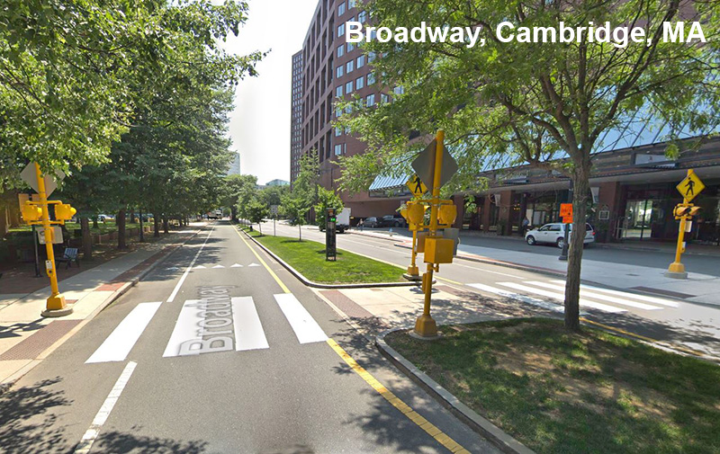
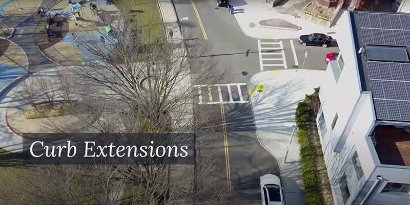
MPO staff recommend tightening the vehicle lanes to 12-foot widths by adding a median between the two travel lanes and creating bump-out pedestrian zones on either side of Route 28. In addition to slowing speeds, narrowing the roadway will make pedestrians more visible to motorists. These changes should also help people hiking feel safer standing closer to the vehicle lanes, which would improve hikers’ ability to see approaching vehicle traffic. Furthermore, by separating the Route 28 crossing into two stages with the addition of the median, pedestrians will only need to wait for a break in one direction of vehicle traffic at a time.
Figure 9 shows an image of a median in Cambridge while Figure 10 illustrates an urban application of a pedestrian bump out. These are typically referred to as curb extensions, but curbs are not present in the study area.
Figure 9
Median/Crossing Island/Pedestrian Refuge
Source: Google Street View (July 2018)
Figure 10
Pedestrian Zone Bump Out (Curb Extension) in an Urban Setting
Source: City of Boston Street Planning and Design Glossary Video (59 seconds)
When making these improvements to the Skyline Trail crossing of Route 28, it will be important to ensure that any changes made to the space are context sensitive. Stakeholders suggested building a wooden structure for the pedestrian bump outs instead of pouring concrete, which would be the typical construction for such pedestrian improvements in an urban setting. Using natural materials or vegetation planters to create pedestrian bump out barriers would minimize the impact of the trail crossing improvements on the natural wildlife habitat. It is important to note, however, that MassDOT has expressed that wooden curb extensions would get damaged by their snowplows and could introduce drainage concerns.
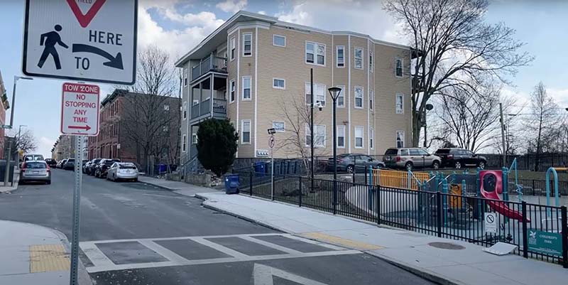
MPO staff recommend creating a raised crosswalk at the crossing location to slow vehicle travel speeds and increase driver awareness that the location is a pedestrian crossing. Figure 11 shows an example of a raised crosswalk. Signage beside the intervention should alert motorists to the change in pavement level. Further clarification from MassDOT will be required as to whether MassDOT will support the installation of raised crossings on state highways.
Figure 11
Raised Crosswalk
Source: City of Boston Street Planning and Design Glossary Video (2 minutes 31 seconds)
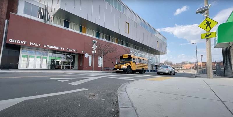
Finally, MPO staff recommend adding rectangular rapid flashing beacons (RRFBs) to the Skyline Trail, one on either side of the raised crosswalk, to alert drivers to the presence of people waiting to cross Route 28. An example of these beacons can be seen in Figure 12.
While the current roadway configuration at the study location qualifies the crossing for a Pedestrian Hybrid Beacon (PHB) according to Federal Highway Administration guidance, MPO staff’s recommendations to install a median as a pedestrian refuge island, add curb bump outs, and slow vehicle speeds would make the Skyline Trail crossing a prime location for RRFBs.6 7 RRFBs can be powered using solar energy, but coordination with and approval from DCR would ensure that the beacons do not have a detrimental impact on wildlife in the vicinity of the Skyline Trail crossing.
MPO staff would support the installation of PHBs at the study location but express concern regarding the cost and amount of time required for such an installation. Providing for the safety of people hiking in the Blue Hills Reservation rapidly may be more feasible with options that are lower in cost and quickly installed, such as RRFBs. Additionally, MPO staff anticipate greater potential for wildlife impact concerns with PHBs than RRFBs.
For these same two reasons of cost and time, the MPO staff have not included a pedestrian bridge among their top improvement recommendations for the Skyline Trail crossing. The Friends of the Blue Hills have expressed their interest in the construction of a pedestrian bridge at the study location and MPO staff support the construction of such a structure for safety purposes. Given how long such a project would take to come to fruition and the wildlife mitigation that a pedestrian bridge would require, MPO staff believe that safety would be most swiftly served by executing the recommendations previously outlined.
Figure 13 summarizes the improvements that MPO staff recommend where the Skyline Trail crosses Route 28 and Table 8 provides time and cost estimates for the modifications recommended by MPO staff.
Figure 12
Rectangular Rapid Flashing Beacons
Source: City of Boston Street Planning and Design Glossary Video (3 minutes 30 seconds)
Table 8
Cost and Time Estimates for Crossing Modifications
Crossing Modification |
Time Estimate |
Cost Estimate |
Crosswalk Markings a |
Short-Term |
$4.50/foot |
Signage |
Short-Term |
$25/square foot installed |
Rumble Strips |
Short-Term |
$900 minimum ($300 per rumble strip, minimum of 3 per day) |
Curb Extensions b c |
Short-Term |
$4,000 |
Rectangular Rapid Flashing Beacons d |
Short-Term |
$12,000‒$15,000 |
Median |
Moderate-Term |
$6,000 |
Raised Crosswalk b e |
Moderate-Term |
$8,500 |
a This estimate assumes a 12-inch Thermoplastic line.
b This estimate does not include the cost of excavation, gravel, safety items, or other roadway construction components. An estimate of $15,000 - $20,000 was provided as the total for both a raised crosswalk across Route 28 and curb extensions on both sides of the roadway. The higher estimate includes excavation, gravel, fine grading, curbing (curved and straight), concrete, hot mix asphalt (HMA), signage, safety additions, and other miscellaneous additions associated with these roadway improvements. Costs are dependent on each contract’s bid prices, so this is a conservative estimate.
c This estimate assumes the use of traditional granite curb extensions with concrete on each side of the roadway. This type of improvement could be quickly implemented using less expensive, natural materials, such as wood and planters, to construct contextually-appropriate curb extensions.
d Rectangular rapid flashing beacons can be installed on signposts (P5) or on signal poles with foundations. The cost varies depending on the type of installation. This cost estimate includes two rectangular rapid flashing beacons, one on either side of a two-lane roadway.
e These calculations assume the use of hot mix asphalt (HMA) for the raised crosswalk.
Figure 13
Skyline Trail Crossing of Route 28 Improvement Recommendations
The proposed improvements for where the Skyline Trail crosses Route 28 will require coordination among the variety of entities that have jurisdiction over elements of the study area: the City of Quincy, MassDOT, MassDOT District 6, and DCR. Furthermore, it will be important for the Friends of the Blue Hills to be involved in this endeavor to ensure that any changes made to the area suit the needs of people hiking along the Skyline Trail.
Implementing the crossing improvements proposed in this study of the Skyline Trail’s intersection with Route 28 will improve safety for all road users. The impact of the changes for people hiking along the Skyline Trail could also increase trail usage and alter behavior patterns. A greater sense of safety and comfort when crossing Route 28 could encourage more hikers to continue to walk along the Skyline Trail rather than turning back upon reaching Route 28. Improvements to this important crossing in the Blue Hills Reservation trail system have the potential to increase access to a much greater area of the nature preserve for all residents throughout the Boston metropolitan region.
1 The Friends of the Blue Hills Reservation’s Find Your Trail Chart states that the route measures nine miles end to end but that the hike is 14-miles long for trail users who culminate their hike where they began. AllTrails describes the Skyline Trail as a 15.2-mile out-and-back route, while DCR’s Blue Hills Reservation map states that the Skyline Traverse is 7.5-miles long. The map explains that there is also the Skyline Loop Trail, which measures 2.6-miles in length.
2 Boston Region Metropolitan Planning Organization (website). Unlocking the Blue Hills (September 2022), accessed May 16, 2024. https://storymaps.arcgis.com/stories/77be5663ee834d37ae73d8f5a98659a4
3 Data for vehicles traveling north of the Skyline Trail crossing were collected from 4:00 PM Tuesday (09.27.22) to 2:00 PM Monday (10.03.22) for northbound traffic and from 1:00 AM Tuesday (09.27.22) to 2:00 PM Monday (10.03.22) for southbound traffic. Data for vehicles traveling south of the Skyline Trail crossing were collected from 1:00 AM Tuesday (09.27.22) to 1:00 PM Monday (10.03.22) for northbound traffic and from 3:00 PM Tuesday (9.27.22) to 1:00 PM Monday (10.03.22) for southbound traffic.
4 The Boston Region MPO’s Eco-Counter Mobile MULTI unit can count both bicyclists and pedestrians, but only the pedestrian counting feature was suitable for the hiking trail location.
5 Data for people walking along the Skyline Trail were collected in December 2022 from 4:00 PM on Friday, December 2, to 2:00 PM on Monday, December 12, and in August 2023 from 3:00 PM on Monday, August 14, to 12:00 PM on Tuesday, August 29.
6 Federal Highway Administration. Guide for Improving Pedestrian Safety at Uncontrolled Crossing Locations (July 2018).
7 Federal Highway Administration. Field Guide for Selecting Countermeasures at Uncontrolled Pedestrian Crossing Locations (July 2018).
Appendices:
Automatic Traffic Recorder (ATR) Data
Vehicle Travel Speed Data
CIVIL RIGHTS NOTICE TO THE PUBLIC Welcome. Bem Vinda. Bienvenido. Akeyi. 欢迎. 歡迎
You are invited to participate in our transportation planning process, free from discrimination. The Boston Region Metropolitan Planning Organization (MPO) is committed to nondiscrimination in all activities and complies with Title VI of the Civil Rights Act of 1964, which prohibits discrimination on the basis of race, color, or national origin (including limited English proficiency). Related federal and state nondiscrimination laws prohibit discrimination on the basis of age, sex, disability, and additional protected characteristics.
For additional information or to file a civil rights complaint, visit www.bostonmpo.org/mpo_non_discrimination.
To request this information in a different language or format, please contact:
Boston Region MPO Title VI Specialist 10 Park Plaza, Suite 2150 Boston, MA 02116 Phone: 857.702.3700 Email: civilrights@ctps.org
For people with hearing or speaking difficulties, connect through the state MassRelay service, www.mass.gov/massrelay. Please allow at least five business days for your request to be fulfilled.
|